brand logo Weather Radar System - Collins Aerospace - MultiScan ThreatTrack - WXR-2100-SINGLE


MultiScan ThreatTrack™ single transceiver weather radar provides atmospheric threat assessment capabilities for air transport aircraft

System configuration as in A system, Dual system DualSingle

Related Products

This works with...

This includes...

Features

  • MultiScan ThreatTrack:
  • Track while scan thunderstorm assessment of developed and fast-growing convective cells
  • Core threat assessment analyzes cells to better represent the actual thunderstorm threat
  • Associated threat assessment with inferred hail and lightning detection
  • Predictive OverFlight Protection tracks and alerts on rapidly building cells below the flight path, assesses estimated 'threat top' not just the radar top
  • Two-level enhanced turbulence detection - certified turbulence display plus "ride quality" turbulence display
  • Hazard Detection:
  • Fully automatic operation
  • Advanced ground clutter suppression at all ranges
  • Enhanced geographic and seasonal weather correlation for maximum worldwide performance
  • Optimized weather detection from 0 to 320 NM and all altitudes
  • OverFlight Protection (prevents inadvertent thunderstorm top penetration)
  • SmartScan real time weather in turns
  • TrueZero antenna compensation
  • Predictive windshear detection with magnitude, velocity and duration data recording and retrieval
  • Variable temperature based gain
  • Certified turbulence detection
  • Redesigned RF section for improved performance and enhanced reliability
  • Demonstrated industry-leading pedestal reliability
  • Simultaneous display updates in all range/mode combinations
  • Split Function Control on some platforms
  • Optional manual mode can be used by crews at any time
  • COMPONENTS:
  • Control Panel WCP-701
  • Antenna Flat Plate Element WFA-701X
  • Antenna Pedestal Mount WMA-701X
  • Transceiver Tray Mount WMT-701X
  • Transceiver WRT-2100

Description

Superior, automatic, clutter-free weather detection and analysis out to 320 nm.
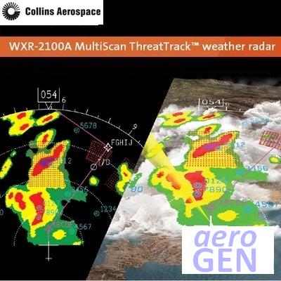
Collins Aerospace MultiScan ThreatTrack weather radar offers an innovative approach to detecting and analyzing weather phenomena and displaying adverse weather threats, enabling safer, smoother and more efficient flights. Global flight tests of the system have validated the performance of the threat detection concept and ensure that the radar makes optimum adjustments to maximize the "probability of detecting" thunderstorms during all phases of flight.

Crews will benefit from additional innovative technologies that go beyond today's most advanced radar systems by adding predictive weather analysis and new threat detection features.

MultiScan ThreatTrack features

  • Patented track-while-scan technology prioritizes weather threats out to 320 nm by performing dedicated horizontal and vertical scans on developed or fast-growing convective cells that pose an actual threat.
  • Core threat assessment examines thunderstorm cells and increases the displayed colors to better represent the actual thunderstorm threat.
  • Associated threat assessment infers lightning, hail and convective threat potential within and external to a thunderstorm core.
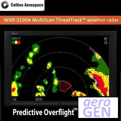
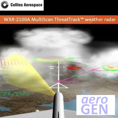
  • Predictive OverFlight protection tracks thunderstorm cells ahead and below the aircraft, measures growth rate, predicts bow-wave turbulence and indicates potential threats in the aircraft's flight path.
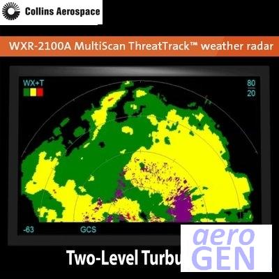
  • Two-level enhanced turbulence detection detects severe and ride-quality turbulence up to 40 nm ahead of the aircraft.
  • Predictive wind shear detection with wind shear event data recording and retrieval.
  • Geographic weather correlation uses a database of geographic and seasonal weather variations that enhance MultiScan ThreatTrack's algorithms to provide accurate worldwide hazard information.
  • Advanced ground clutter suppression eliminates ground clutter on the weather display at all ranges, allowing pilots to concentrate exclusively on true weather threats.
  • Track-while-scan thunderstorm assessment out to 320 nm
  • Core threat assessment increases display colors based on potential threat
  • Associated threat assessment with inferred hail and lightning threats outside of the cell
  • Predictive OverFlight protection tracks and alerts on rapidly building cells in the flight path
  • Two-level enhanced turbulence detection - certified turbulence plus ride-quality turbulence displays

Additional features

  • Fully automatic operation
  • Advanced ground clutter suppression at all ranges
  • Enhanced geographic and seasonal weather correlation for maximum worldwide performance
  • Optimized weather detection from 0 to 320 nm and all altitudes
  • OverFlight protection (prevents inadvertent thunderstorm top penetration)
  • SmartScan real-time weather during turns
  • TrueZero antenna compensation
  • Variable, temperature-based gain
  • Predictive wind shear detection with wind shear event data recording and retrieval
  • Redesigned RF section for improved performance and enhanced reliability
  • Demonstrated, industry-leading pedestal reliability
  • Simultaneous display updates in all range/mode combinations
  • Split function control on some platforms
  • Optional manual mode can be used by crews at any time

Available Modes

  • MultiScan ThreatTrack automatic operation
  • Ground map
  • Weather
  • Weather plus turbulence
  • Wind shear detection (takeoff and landing flight phases)
  • Turbulence detection
  • Manual operations - independent - mode, gain, tilt, range for each pilot
  • Manual gain available in all modes

Overall System Specifications

  • General ARINC 708, 708A, 429, 453, 600
  • TSO C63c
  • Interfaces TCAS, ACARS, EFIS, CMC/CFDS, radio altimeter, EGPWS, DAD C, IRS or ADIRU
  • Environmental RTCA DO-160E
  • Software RTCA DO-178B Level C
  • Performance index (avoidance)
  • X-Band 236 dB (580 nm range)

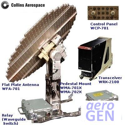
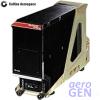
Receiver-transmitter

  • Size Per ARINC 708A
  • Weight 23.1 lbs max
  • Input power 115 V ac plus/minus 10%, 400 plus/minus 20 Hz single phase
  • Power dissipated 120 watts or less

Transmitter

  • PRF 180 (up to 3,000) pp/s
  • Pulse widths 1 to 25 microseconds
  • Frequency (direct 9.33 GHz digital synthesis)
  • Peak power 150 watts nom

Receiver

  • Noise figure 3.8 dB
  • Bandwidth 32 MHz
  • Minimum discernible TBD signal
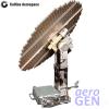
Antenna

  • First side lobe -31 dB
  • Stabilization type Full stabilization - all modes
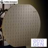
  • Type Flat plate
  • Beam width 10 degrees
  • Gain 34.5 dB nom

Source Collins Aerospace document 147-0624-004 03/14 © 2014

Product Detail

item
Item type Weather Radar System
identity
Primary identity code for a product or service WXR-2100-SINGLE
Product brand Collins Aerospace
Product brand previous Rockwell Collins
Item code/part number WXR-2100-SINGLE
company
United States Commercial And Government Entity code for company manufacturing this product 4V792
Manufacturer or vendor division that manufactured this product Commercial Systems
coordinate physical
Full postal address for this facility 400 Collins Road North East, Cedar Rapids, Iowa, 52498, United States
Continent covered Americas
Geographic location of this facility within the continent 1-North
coordinate virtual
Reception phone; format is country code (dialling prefix of 00 shown; replace with your local code as required), area code, facility discrete number 001 319 295 1000
001 888 265 5467
United States Commercial and Government Entity supplier code for this facility 4V792
marketing
Production start date 2014-02-04
System name MultiScan ThreatTrack
System code WXR-2100
norm
Standard/Norm ARINC 708
ARINC 708A
ARINC 429
ARINC 453
ARINC 600
FAA TSO-C63c
RTCA DO-160
RTCA DO-178C
RTCA DO-178C Level C
measurement
Typical system weight 17.4 kg
38.4 lb
electrical electronic
Nominal voltage alternating current 115 volt
Number of electrical power supply phases used Single
Frequency 400 to 800 Hz
Power in watts 120 to 150 W
system
Airlines For America Specification 2200 system and sub-system title Navigation Position Determine Independent; Weather Radar
Joint Aircraft System Component title Weather Radar
System configuration as in A system, Dual system Single
Airlines For America Specification 2200 system and sub-system title assigned by manufacturer 34-45
Airlines For America Specification 2200 system and sub-system code 34-40
Joint Aircraft System Component code 3442
information publish
Date first published; date format is to International Standards Organisation Standard 8601/European Norm 28601; YYYY-MM-DD 2014-02-04
facility
region_trade NAFTA
Sovereign country covered United States
region_state Iowa
access airport
Nearest airport to the company facility The Eastern Iowa
Airlines For America code for the nearest airport to the company facility CID
time zone
Time zone code for facility CST
Coordinated universal time (UTC) difference; UTC 00-00-00 is, within about 1 second, the mean solar time at 0 degrees longitude; Greenwich mean time is close to UTC 00-00 UTC minus 06:00
Coordinated universal time (UTC) difference for Summer; UTC 00-00-00 is, within about 1 second, the mean solar time at 0 degrees longitude; Greenwich mean time is close to UTC 00-00 UTC minus 04:00
Month range when daylight saving time is applied March to November