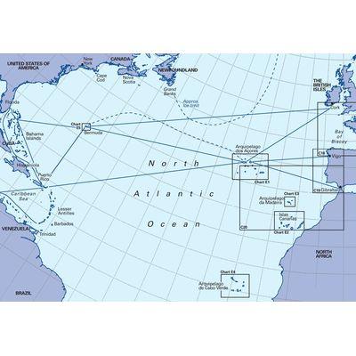
Chart Nautical - Imray - 100 9780852889800


Nautical passage for North Atlantic from Brazil to Newfoundland and Gibraltar to Caribbean

Chart Nautical - Imray - 100 9780852889800 thumbnailthumbnail

Description

Interestingly it has been constructed on a conical projection which means that Great Circle tracks can be plotted as straight lines rather than curves

The shows the main trend of contours, lits of ice, magnetic variations and keys routes as identified by D M Street

On the reverse are notes on the routes and small wind rose charts, with accompanying charts showing excessive wave heights and storm frequencies for the months that yachts cross the Atlantic, April to July and October to December

This chart will be an important companion for Atlantic Yachtsmen on passage and an excellent source of planning information

Product Detail

item
Item type Chart nautical
identity
Primary identity code for a product or service 9780852889800
Product brand Imray
Product range Ocean Series
Original title North Atlantic Ocean Passage Chart
sale
Quantity of items per container for retail sale 1 per-pack
Global Trade Item Number / International Article Number / European Article Number code of retail pack 9780852889800
marketing
Model code 100
information
Subject covered Navigation
information publish
Master document publication date 20061100
Media used for publication of this information; primary Paper
Information output media form; primary Sheet
cartography
Chart/map measurement system WGS 84
Chart or map area covered North Atlantic Ocean Passage Chart 1:7620000
location geographic
Ocean coverage North Atlantic